Tag Archives: tourism amlan

Sulphur Lagoon, twin falls and a mining tunnel

81636356_3951465904879120_4792648010108502016_o

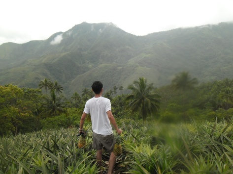
Negros island never fails me to different unique destinations. The seemingly boundless mountains will give you a glance of its hidden gems. The thick foliage where a home of undiscovered adventures and the foothills of untouched beauty will tell you to go further. This week, we will explore what’s in those mountains en route bordering the city of Tanjay and the towns of Amlan and Pamplona in Negros Oriental. People were talking of this unique lagoon in the middle of the forests where I was thrilled to set foot.

Brgy Jantianon in Amlan though the farthest village in that area is not new to me as I’ve been there twice sometime in year 2016. Through the years, my third visit was somewhat a new experience. Further up the main Brgy of Jantianon, things and sights have changed. The road for instance has a huge development since my last visit. As I could remember, that part were unpaved on those times were the ones that made me think not to go again in the future. Now the way has been better, it was a smooth and scenic drive. The easy drive made me forget the way to Sitio Badiang, the jump off area to Naibid waterfalls.

The paving of the road up to its hinterland areas in Sitio Canete continues as there is still a long way to complete the road. What we are aiming that time is a lagoon in the middle of the wilderness bordering the towns of Amlan town, Pamplona and Tanjay City. Though its actually under Brgy Ling ab Tanjay City, the easiest way to get there is through Jantianon Amlan, and is geographically located behind Palaypay falls in Pamplona municipality.

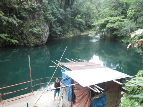
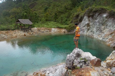
“Asupre sa Maiti” as locals would call it is a lagoon where the waters is sulfuric in content. To name some similar destinations here in the province with the same character are Pulangbato falls in Valencia, the falls due to its reddish rocks is a sign of the natural chemical, if explored further the source which is hot in nature comes from a rock then adjoins the river. The nearby Palaypay falls is also sulfuric in nature of which I presume its sulfur properties is the same of that in this lagoon. Mainit falls in Dauin is also the same, the source which is continually explored by EDC has steaming hot water and an aggressive chemical odor, no wonder it reaches up to the highlands of Tanjay and Amlan, as it is widely distributed in nature specifically on volcanic regions.

81949258_3951464711545906_3375393585082925056_o

We arrived at the jump off point for our vehicles, a sign welcomes us that we are at Brgy Ling-ab, under Tanjay City. The jump off point is situated in its satellite market built by OPAPP (Office of the Presidential Adviser for the Peace Process). The area is governed by the members of resettled community guided with the Department of Environment and Natural Resources. If we could have arrived earlier that day, we could have witness how’s the grind it the market, unfortunately we arrived late morning. Anyways, we were asked on our purpose of the visit, then register our names on their logbook. There was no entrance fee collected as of now.

82295346_3951464408212603_7344070231330914304_o

81961710_3951458731546504_9205604551720173568_o

81939596_3951458368213207_6733622861648363520_o

81933142_3951461084879602_89029513790357504_o

81852480_3951462758212768_5191915312475275264_o

81581547_3951462344879476_5251514567892140032_o

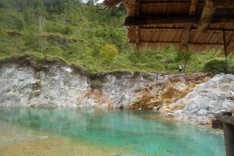
We were accompanied by a local resident from Jantianon Amlan whom we share a few friends in common and voluntarily guided us. From the satellite market, we walked through a forested area at about 1.2 kilometers, most of the portions of the trail are wet and murky. We followed him for at least 15 minutes or so. The sulfur lagoon is literally enclosed on mountains and woodland. The two native huts were a welcome sign from a distance that we have reached our destination.

81533535_3951459514879759_6100103485997449216_o

81524527_3951465058212538_5662456824025055232_o

81511071_3951464051545972_4303289443676061696_o

81431579_3951463651546012_5148275657314140160_o

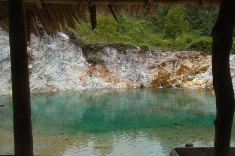
There was no one when we arrive, and it means it will all by ourselves to explore. The lagoon has a clear tinge of blue waters where we could clearly see what’s underneath. The spring comes out on rocks, and when closely observed, it smells an assertive content of its waters. The community had to dig the surrounding the source to hold the water to create a basin before it flows directly to a channel. Though sulfuric, the water is extremely cold. Taking a dip was a must experience as the depth is measurable to swim.

81382825_3951457628213281_1710448494881275904_o

81230258_3951461424879568_5451291424022593536_o

81138096_3951460611546316_3186155882912153600_o

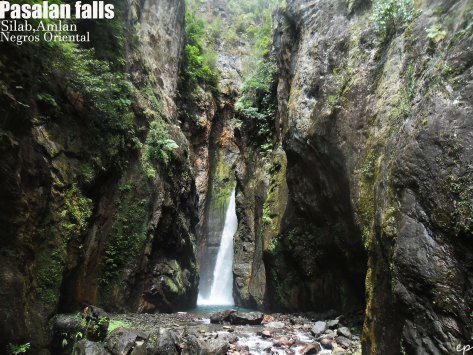
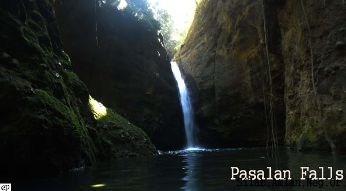
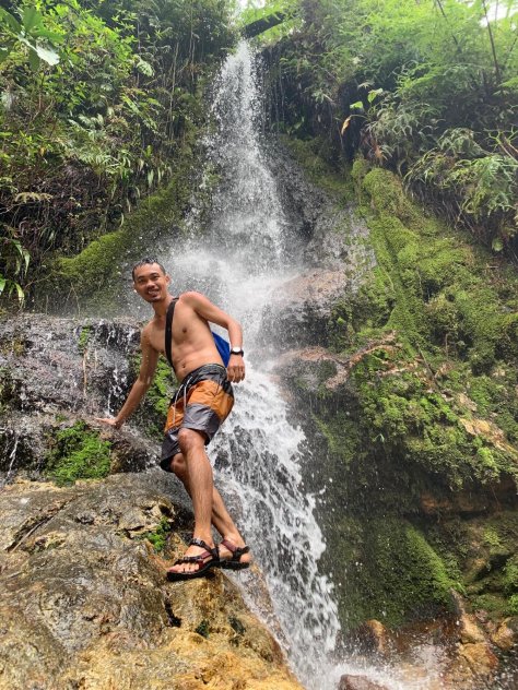
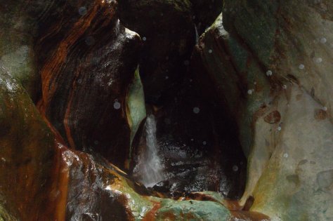
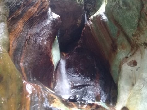
The weather started to change in the highlands when we left the area. And before we turn back at usual route, our guide led us to its adjacent twin waterfalls. As you all know I always get excited whenever I hear of a waterfall destination. We made it to the river in less than 5 minutes; we descended a slope to the river where we could already notice the first waterfalls flowing on an average height. The second falls, which was only a few steps is concealed by rock canyons and will only be visible if you jump off to the water to have a clearer view. Without hesitation, I jump onto its waters then quickly made it to the bank. The rock canyons on both sides where somewhat a mixture of red and portions of black, mossy green, some white and brown. The water flows from huge boulders above it and some other rocks where stocked in between canyons. Wasn’t really the best view but I am always fascinated in it by any forms.

81257195_3951465291545848_5425646913032552448_o

81886405_3951465591545818_3264853960246165504_o

81382846_3951459198213124_4252723260396929024_o

82047430_3951461851546192_5213350639551119360_o

81950334_3951460204879690_6011874236283486208_o

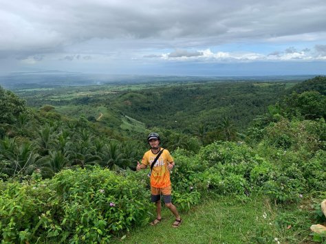
And so we left the falls wet. We hurriedly went back to the satellite market as fog slowly rolls out the forests. Our third stop to end our day is an old abandoned tunnel. Along our way to the tunnel we had to stopped on a small plateau, it has nothing but just a nice overlooking views of the lowlands, the ocean is in its usual form, the Cebu island was a steady sight, and the mountain sides north as far as Bais City.

81711048_3951459834879727_5182411859814252544_o

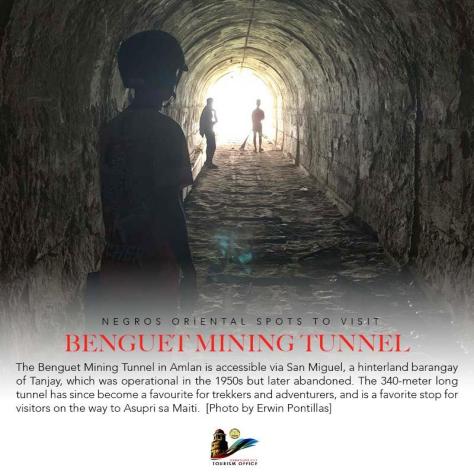
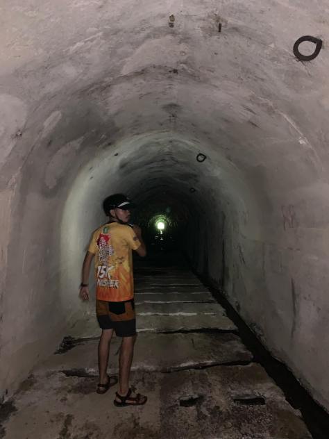
A few meters away from the overlooking area, we stopped in a discreet way where the underground passage is situated. There was no sign and markings on its existence but on our way we noticed this some kind of ancient stone walls piled along the road, there were somewhat old structures abandoned for a long time. We descended quickly to the side down to its entrance. From our entry point we could see a domed patch of light to the other end. Actually both ends can be an entry point or otherwise the exit point. The Benguet Mining Tunnel measures around 340 meters long and can be explored from end to end. In relation with the sulfur areas, this tunnel were once used as a passageway among miners in the late 1950’s were minerals are heavily mined. We slowly walked through its darkness never losing the sight of the other end. There is an echoing silence inside; we could clearly hear the droplets from side to side, and the sound of our steps and stops. There were couple of bats flying over its darkness, and hoping not to stumble on a resting reptile in the ground. We made it to the other end, which serves as a window to the other overlooking view; the mountains on that side were a sight of abundant greens and its jungle. The composition of the tunnel definitely tells a history on its operations way back then.


81063532_3921583141200730_499563571936493568_o

81672297_3921585014533876_6813449488884039680_o

81040625_3921584231200621_5868444400434020352_o

80687680_3921584301200614_4879710884143824896_o

80655547_3921587674533610_8151405838234288128_o

80573570_3921578621201182_4962733345004847104_o (1)

80474091_3921587794533598_8174966650135642112_o

80367397_3921584287867282_6146435965394092032_o


We ended the day by just halting a few minutes to some overlooking zones while enjoying the highlands under its shades, we drove along rivers where I am always curious of what’s waiting up there, and we’ve learned locale stories so as interesting things to do.

Just when I thought I’ve seen almost the destinations in Amlan, these were added on our conquered lists. There could be more. Do you know any interesting spot in your area? We’d like to know, drop down in the comment section and together we will discover more.

82465904_839028643187248_4525800863079333888_n
Posts from Dumaguete City Tourism Office


Silab, Amlan, Negros Oriental

SAM_4950

SAM_4975

Nature’s greatest secrets are always hidden in the most unlikely places. Recently I explored one of the most difficult road driving trails en route to the hinterlands of Silab, Amlan in Negros Oriental but difficult roads have always been a manifestation to a beautiful destination.

Nature has combined this unique natural topography with extensive vegetation and sleepy mountains in this town. The wet road surface and forest terrain conditions on rainy season make access more difficult. I have no idea where I am heading to, and I have no contact person in the area making this a challenging trip.

From a quick visit to Amlan Zoo, my mind was shifted to that huge river, running along Brgy Tambojangin. There could be waterfalls up on those mountains I am staring. From the animal park, an elevated road will lead to the next Brgy of Silab.

Brgy Silab being an agricultural area, the surrounding lands is utilize on usual crops, wide fields of sugarcane, there were few rice plantations, coconuts, bananas, among others, while I noticed most of the crops grown uplands were pineapple, cabbage, corns, variety of vegetables, pepper and some others.

Though developments are now slowly seen specifically on road projects on the remote areas of Silab, mountainous areas still remain unassisted. Sitio Pasalan, the farthest village in the Brgy will hopefully be more accessible in the coming years by the government through farm to market roads.

The road accessibility in Pasalan is actually associated with its power facility. Yes, there is a Powerplant in Amlan. The AHPP  is a 0.8 MW Powerplant facility constructed last 1958 and was ordered for commissioning in the year 1962. The high discharge rate of the river are believed to be springs of underground outlets of Lake Balinsasayao and Lake Danao in Sibulan. The connecting tributaries has several interesting waterfalls I aimed to see.

As mandated, the National Power Corporation (Napocor) first manages this part of Amlan water resources for power generation designed to operate as a base-load plant supplying power to the town of Amlan and nearby villages. It was on year 2009, that Amlan Hydro-electric Power Plant formally turned over to ICS Renewables by The Power Sector Assets and Liabilities Management Corporation (PSALM) for privatization. With the huge amount of water volume, that part of Pasalan is suited for the facility, hiding behind steep slopes are numerous waterfalls, one of which is Pasalan falls.

How did I get there:

From the central Brgy of Cantalina, road condition up to the Powerplant is undeniably unfavorable for vehicles. Nevertheless, I took the courage to drive up to where I could draw close to my destination. Slowly driving up are scenic views on both sides of the road. There were literally no one to ask, there were also few simple cabins along but no one is around, except to that last hut I approach.

It was a timely stop, a person comes out to that shelter as he also saw me coming. Jonard and his family owns the little hut, he narrated that he grew up in the area and had lived in that house for a year before moving to the central Cantalina village. That hour, he was with his older brother whom also helps him frequently cultivating their farmlands. Taking the opportunity to talk with them, Jonard was the right person to ask about Pasalan falls. He volunteered to guide me as well as interesting spots to see. Growing up in the area, the rivers are their playground whereas also serves the second source of their food. The river beds were home of abundant fishes, crabs and freshwater shrimps. I couldn’t ask for more, they were one of the most accommodating locals I’ve met.

From their hut, he drove me along terrible road, this is what I’m talking about, I could have stuck on those pond-like filled with muds or get lost as the worst. I’m amazed how Jonard handles the condition, not to mention, his previous work as a habal-habal driver gives him an edge to drive easily.

Pasalan Dam

20161204_134548

Our first stop, Pasalan Dam and water reservoir situated just on top of Pasalan falls. We managed to arrive at around 30 minutes from their hut to the jump off point for vehicles, we walk through a thick forests I never thought this town has. Jonard told me that the area were once a den of rebel groups, moreover, gunshots were a usual sounds they hear but now seems to be the opposite of what has been a chaotic environment they are living. Around 10 minutes we arrive to this barrier constructed to hold back water and raise its level forming a reservoir used to generate electricity in the Powerplant. The reservoir sits in the middle of a forest, the flowing waters were extremely very cold probably were ground springs from the twin lakes. To the corner is an outpost guarded by a person on duty whom mostly are relatives of Jonard. The area has some errie vibe, in fact, the person on duty tells experiences of strange sounds of a woman, he even sees unnatural sightings within the forests.

SAM_2822


Kang-ontol/Kan-ontol falls

SAM_5051

Visitors wanting to explore Pasalan falls will have to enter the Amlan Hydro-electric Powerplant premises, the property is gated and is mostly open to the public providing the purpose of your visit. Jonard being well known by many including the staff of the facility makes us to access immediately. The Powerplant system is situated at the bottom, both sides of the facility has river systems of which plays an important role in generating electricity. How does electricity works on flowing water? The impoundment facility, typically has large hydropower system uses a dam to store river water in a reservoir. Water released from the reservoir flows through a turbine, spinning it, which in turn activates a generator to produce electricity. The water may be released either to meet changing electricity needs or to maintain a constant reservoir level. From the building, we hike through huge boulders, but before Pasalan falls, there is another waterfall hiding on a cliff rock, who wouldn’t notice a resounding drop, we had to stop. Kang-ontol falls has such a mighty sight.  Further up is the highlight of our significant trip.

SAM_5053


Pasalan falls

pas22

This is what I am very excited, there were just a few people I know who had climb up to that portion. True enough, double extra large boulders are obstructing the way. We climb, we have to crawl, and penetrate a limited size cavity just to reach the bottom part of the waterfalls. Just a few meters of Pasalan, the basin is stirred by waves caused by mighty drops of large amount of water. Both sides of the picture has towering canyons. Part of the whole waterfall is visible, attempting to view the entire height of the falls seems impossible. Fortunately, seeing it in real makes me appreciate more on our province. There is more to explore and discover.

pas33

SAM_4967

SAM_4973

SAM_5050

SAM_4981

SAM_5024

After a fulfilling day, Jonard ended the tour with a quick visit to their backyard and farmland. Further side of a hill, something sweetens my day with an expansive land of pineapples. Another thing to be thankful with him, he let me pick pineapples I want and bring it home. What a rewarding day, wish I could bring many but I can only carry two. Later he told me that the fruits will be sold to the provincial market. Not just that, they also supply variety of vegetables in the trade.

SAM_5068

SAM_5067


Pasalan Falls-Silab,Amlan

Many of the earth’s natural wonders are hidden from view,one of which is Naparil waterfall.

pas2

It lies on a remote area abundantly sheltered with trees in Cantalina Village, Brgy.Silab in the town of Amlan,Negros Oriental. Brgy. Silab is next to Brgy.Tambojangin  where Amlan Zoo and Adventure Park is stationed. Since I’m already close to Silab I drove my way immediately to the last sitio. Asking the locals is still the most efficient way to locate the hidden waterfall. Making sure that I don’t get lost, I always ask any person I meet in the road. Some parts of the road were still unpaved with cement but was a bearable drive.

I reached into a remote mountain slope area where there are a lot of banana plants and trees and a native house nearby. I approached the man on it and asked him the way to the waterfalls. He then pointed to a descending surface which I followed at once. In a slow pace, I move downward perceiving any sound of a gushing river stream.

Later, I was on a flat surface of a huge rock and a continuous flowing water towards a deep gorge with steep sides. I know for sure that is Pasalan falls. Since I have an ample time to explore the area, I moved further up the river stream thinking possibly I could discover a series of waterfall along.

pas3

To my surprise, I found this section with a natural pool filled with cool waters in a shade of blue and green. The water was tempting for a brief swim. I spent a little time of thinking whether to take a dip but I wasn’t sure of how deep it was  so I decided not to bathe.

pas1

On my way back, I was directed by my mind towards the way of how to move below a very steep ravine where I could discern visually the waterfall. I remembered the man I asked at the house and mentioned that going down is very difficult. Therefore, it is not impossible to reach the bottom. All of a sudden, I saw a narrow track of which I don’t know where it leads to but still I followed. The end thereof was a huge tree with huge roots attached down the bottom of the valley.

pas4

Slowly but surely, firmly holding the roots I moved down until I reached the bottom part. From there, I could hear the flowing waters of Pasalan. Finally, in just a few steps its beauty revealed, surrounded with prolific vegetation and high grounds. Now a secret no more.

pas6

pas7